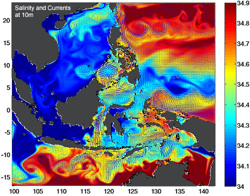
Ocean circulation models are three-dimensional representations of the ocean which are used for studying ocean circulation, climate change, organism distribution and dispersal, marine chemistry, and the distribution and transport of substances in the ocean, including sediments and marine pollutants. These models include factors such as surface air temperature, water temperature and salinity, wind forcing, ocean eddies, and realistic coastline and seafloor features in their calculations. Numerical models can include real-time oceanographic data from ships and satellites to produce forecasts of oceanic conditions, including the El Niño in the Pacific, and the position of the Gulf Stream in the Atlantic.
Types of Circulation Models
There are two main classes of ocean circulation models:
- Mechanistic models are simplified models used for studying processes. Because the models are simplified, the output is easier to interpret than output from more complex models. Many different types of simplified models have been developed, including models for describing planetary waves, the interaction of the flow with sea-floor features, or the response of the upper ocean to the wind. These are perhaps the most useful of all models because they provide insight into the physical mechanisms influencing the ocean.
- Simulation models are used for calculating realistic circulation of oceanic regions. These models are often very complex because all important processes are included, and the output may often be difficult to interpret.
All models must be be initially run for a period of time before they can be used to simulate the ocean. Spin-up is the time taken for an ocean model to reach a state of equilibrium under the applied forcing. Models are started from rest with values entered for density, and are then run for a decade (model time) using mean-annual wind stress, heat fluxes, and water flux. The model may be run for several more years (model time) using monthly wind stress, heat fluxes, and water fluxes. At this point, the model has (hopefully) reached a state of equilibrium and can be used for predictions.
Simulation ocean circulation models can vary in terms of the model coverage area. Ocean general circulation models (OGCMs) are global in their coverage. Other models may be regional or coastal. Regional models look at the interaction of coastal current systems with the circulation patterns further offshore in a specific region (e.g., the NE Pacific Ocean). Coastal models extend from the beach to the continental slope, and may include realistic coasts and bottom features, river runoff, and atmospheric forcing in their calculations. The great economic importance of the coastal zone has led to the development of many different numerical models for describing coastal currents, tides, and storm surges.
Ocean Ecology studied a number of regional and coastal ocean circulation models and their applications to the BC coast. Two of the major models which we investigated are described below.
Regional Ocean Modeling System
ROMS is designed for accurate, high-resolution simulations of regional oceanic systems. It is widely used for studying the interaction between coastal current systems and currents in offshore gyres (e.g., the California Current). ROMS is a hydrostatic (depending on the balance between gravity and pressure resulting from density gradients), primitive equation (depending on conservation of momentum, thermal energy balance between heat sources and sinks, and conservation of mass), terrain-following (depending on bathymetry) model. An example of a predicted surface temperature and current pattern generated by ROMS is shown below.

ROMS has a number of modules, including:
- Biogeochemical models
- Sediment models
- Wave models
- Sea-ice models
ADCIRC
ADCIRC (Advanced Circulation Model for Oceanic, Coastal and Estuarine Waters) is a coastal circulation and storm surge model. It consists of a system of computer programs which solve time dependent, free surface circulation and transport problems in two and three dimensions. These programs utilize the finite element method in space allowing the use of highly flexible, unstructured grids. Typical ADCIRC applications have included:
- Modeling tides and wind driven circulation.
- Analysis of hurricane storm surge and flooding.
- Dredging feasibility and material disposal studies.
- Larval transport studies.
- Near shore marine operations.

